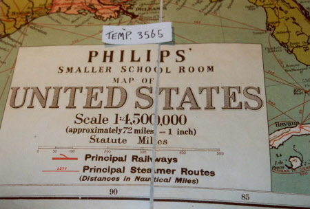
Map of the United States of America
George Philip and Son
Category
Maps
Date
Unknown
Materials
Paper and fabric
Measurements
1128 mm (length); 875 mm (height)
Order this imageCollection
Sudbury Hall Museum of Childhood, Derbyshire
NT 667950
Summary
A large school map of the United States of America, printed in colour ink on paper with a white fabric backing. At the top left and right hand corners are circular copper edged holes to hang the map on the wall. The map has an inscription within a rectangular border at the bottom giving the manufacturer's name, 'Philips', the scale and symbols illustrating the 'Principle Railways' and 'Principle Steamer Routes'. The map itself has each state of America printed in a different colour. Other countries, Canada, Mexico, Cuba and the Bahamas, are also shown but are printed in white, although towns and cities are still marked. Within the bottom margin, further manufacturing information is given. On the back of the map is part of a paper label reading 'Philips' Small School-room Map of United States' in black ink. Part of this inscription has been torn away. Stamped with a purple stamp within a rectangle in several places is 'The Property of the Staffordshire Education Committee.' Parts of the backing is covered with blue paper. Parts of the map is covered with dirt and mould and the rings have gone green.
Marks and inscriptions
On the bottom of the map, within a rectangle: 'PHILIPS' / SMALLER SCHOOL ROOM / MAP OF / UNITED STATES / Scale 1 (colon) 4,500,000 / (approximately 72 miles (equals sign) 1 inch) / Statute Miles / Principle Railways / Principle Steamer Routes / (Distances in Nautical Miles)' On the bottom of the map: 'GEORGE PHILIP AND SON, LTD., THE LONDON GEOGRAPHICAL INSTITUTE. / DBB.' On the back of the map, inside a rectangle: 'The Property of / the Staffordshire / Education Committee'
Makers and roles
George Philip and Son , maker

