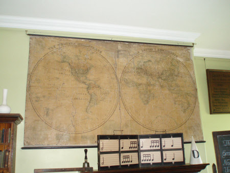
A world map
Stanford's Ltd.
Category
Maps
Date
1 Oct 1875
Materials
Linen, wood and paper
Measurements
2610 mm (width); 1505 mm (height)
Place of origin
Charing Cross, 55
Order this imageCollection
Sudbury Hall Museum of Childhood, Derbyshire
NT 665329
Summary
A world map (1875) printed on paper with a linen backing and nailed to two wooden battens, one at the top and one at the bottom. Some details are painted in green. The Western Hemisphere is on the left and the Eastern Hemisphere on the right. At the centre bottom are the Land and South Hemispheres to left and right respectively. In the left hand bottom corner is the Water Hemisphere and in the right hand bottom corner is the North Hemisphere. To the right of the Water Hemisphere is MERCATOR'S PROJECTION/ BETWEEN 75 DEGREES NORTH AND 7O DEGREES SOUTH LATITUDE/ AND THE GORES OF A GLOBE/ COMPLETE on the same scale at the Equator. To the left of the North Hemisphere is A COMPARATIVE SERIES OF VERTICAL SECTIONS/ Sections A.B.C. show the principal d[][]ations of each continent on their respective parallels of latitude: [ ]ons D.E. show them as they stand related to each other in their distances from the central meridian.
Marks and inscriptions
Bottom left-hand side of the map: 'Sold at the Depositories, 77, Great Queen Street Lincoln's Inn Fields, W.C.; 4, Royal Exchange, E.C.; 48, Piccadilly, W.; and the Sanctury, Westminster; also by Edward Stanford, 55 Charing Cross, London. October 1st 1875.' Bottom right-hand side of the map: 'Sold at the Depositories, 77, Great Queen Street Lincoln's Inn Fields, W.C.; 4, Royal Exchange, E.C.; 48, Piccadilly, W.; and the Sanctury, Westminster; also by Edward Stanford, 55 Charing Cross, London. December 1st 1875.'
Makers and roles
Stanford's Ltd. , engraver and publisher
