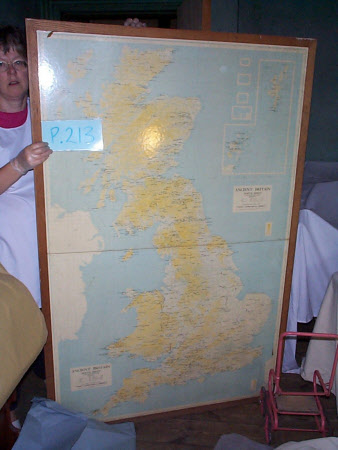
Wall map of Great Britain
Ordnance Survey (England, Scotland, Wales)
Category
Maps
Date
1964
Materials
Paper, plastic and wood
Measurements
Map - 1040 mm (width); 1620 mm (height), Frame - 1110 mm (width); 1685 mm (height)
Place of origin
Chessington
Order this imageCollection
Sudbury Hall Museum of Childhood, Derbyshire
NT 663845
Summary
A large wall map of Great Britain printed on paper coated with transparent plastic. This is framed in a plain wooden frame. It comprises two sheets - one labelled 'Ancient Britain (North Sheet)' and 'Ancient Britain (South Sheet)'. In the top right hand corner is an inset showing the Orkney and Shetland islands. This map was produced by the Ordnance Survey in 1964 and the scale reads 'Scale:1/625,000 or about Ten Miles to One Inch'.
Marks and inscriptions
Both north and south sheets: 'ANCIENT BRITAIN/ (NORTH SHEET) [ALSO SOUTH SHEET]/ A MAP OF THE MAJOR VISIBLE ANTIQUITIES/ OF GREAT BRITAIN OLDER THAN AD. 1066/ Printed and published by the Director General of the ORDNANCE SURVEY, CHESSINGTON, SURREY, 1964./ Crown Copyright. 1964' Sheet of paper pasted to the reverse of the map: 'COUNTY BOROUGH OF DERBY EDUCATION COMMITTEE/ SCHOOLS LOAN SERVICE/ VISUAL UNIT/ ANCIENT BRITAIN/ 1. Framed Ordnance Survey Map on scale 1/625,000/2. MODELS SET NO. 163 - Stonehenge/ SET NO. 85 - Model of a Prehistoric Lake Dwelling/ 3. FILMS/ SD. 118 - Beginning of History Part I/ SD. 120 do. Part II/ SD. 121 do. Part III/ 4. FILMSTRIPS/ UNICORN HEAD - f.2735 - Hunters of the Stone Age/ do. - F.2907 - Farmers of the New Stone Age/ do. - F. 2736 - The Bronze Age/ COMMON GROUND - F. 2334 - Cave Men and Hunters/ TARTAN - F. 2445 - Prehistoric Mounds and Standing Stones/ COMMON GROUND - F.2895 - Farmers and Craftsmen (Living before History)/ V.I.S. - F. 3898 - Early Britain - Part I/ V.I.S. - F. 3899 do. - Part II' Label on the reverse of the map: 'The surface of this map has been/ treated with a special plastic/ which will take ball point ink./ To remove ink wipe with a damp/ cloth.' Label on the reverse of the map: 'FINE ART DEALERS/ PICTURE FRAMERS/ ARTISTS' COLOURMEN/ J. Pratt and Sons/ (DERBY) Limited/ 31 CURZON STREET/ DERBY/ Estd. 1887 Tel. 48132'
Makers and roles
Ordnance Survey (England, Scotland, Wales) , maker
