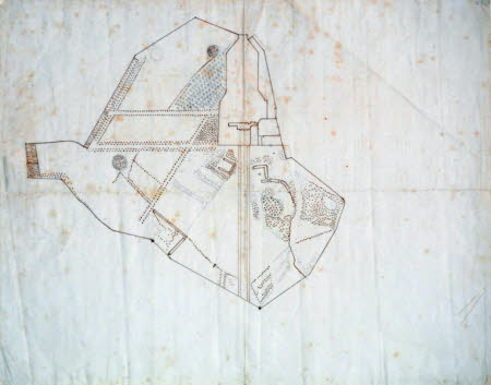
Survey plan of the Park to the south, west and north of the house at Wimpole, Cambridgeshire
Charles Bridgeman (d.1738)
Category
Architecture / Drawings
Date
circa 1720
Materials
Pen and ink with pencil
Measurements
333 x 420 mm
Place of origin
England
Order this imageCollection
Wimpole, Cambridgeshire
NT 206242
Summary
Charles Bridgeman (d. 1738). Survey drawing of the Park to the south, west and north of the house, c. 1720, pen and ink with pencil (333 x 420mm), scale not given, watermark: LVG, PRO PATRIA with lion and Britannia within a palisaded enclosure and a bell beneath.
Full description
Peter Willis included this in his 1993 essay 'Charles Bridgeman and the English Landscape Garden: New Documents and Attributions' but, doubtful about its authorship, excluded it from the second edition (2002) of his monograph on Bridgeman. It does nonetheless appear to relate to Nos. 29 & 30 [1] . This is a fairly roughly inked survey plan of the pre-Bridgemanic landscape, in part drawn over pencil set-up lines, but which appears to include several proposed features. Phibbs argues that the double lime avenue, shown here striking westwards from the south-west corner of the garden boundary, and running up to meet the southern end of the diagonal fir avenue, was one of Bridgeman's contributions. However, the avenue is here plotted in ink, and the slight irregularity of the trees perhaps suggests that it is a record rather than a proposal. More certainly new elements, and here finding their first tentative expression, are the triangular-shaped and regimented planting of lollipop-headed trees, drawn in pencil, to the northwest of the house (which was to become Bridgeman's 'grid' of lime and horse-chestnut), and the great south avenue, here indicated by the faux quincunx pattern of planting, pencilled in between ruled tramlines. The vista to Whaddon church is also shown and the westernmost of the spiral of fish ponds to the south-east of the house, that lay along the path of the clairvoyée, is removed. From the outset Bridgeman clearly decided that Chicheley's south avenue should be replaced with an even grander one. Bridgeman also records in pencil the position of the ring-shaped earthwork to the east of the northern end of the Fir Avenue - this was to serve as the focus of a diagonal avenue which he subsequently proposed .The drawing is clearly unfinished. Catalogue entry adapted from David Adshead, Wimpole Architectural drawings and topographical views, The National Trust, 2007 [1] David Adshead, Wimpole architectural drawings and topographical views, The National Trust, 2007, pp. 29 - 33, nos. 29 & 30.
Provenance
Edward Harley, 2nd Earl of Oxford (1689 – 1741); bequeathed by Elsie Kipling, Mrs George Bambridge (1896 – 1976), daughter of Rudyard Kipling, to the National Trust together with Wimpole Hall, all its contents and an estate of 3000 acres.
Marks and inscriptions
Watermark: LVG, PRO PATRIA with lion and Britannia within a palisaded enclosure and a bell beneath
Makers and roles
Charles Bridgeman (d.1738), garden designer
References
Adshead 2007: David Adshead, Wimpole Architectural drawings and topographical views, The National Trust, 2007, p. 33, no. 32 Willis 1993: Peter Willis, 'Charles Bridgeman and the English Landscape Garden: New Documents and Attributions', English Architecture Public and Private: Essays for Kerry Downes, (ed. John Bold and Edward Chaney), 1993, pp. 246-64, p. 261, fig 103 (a)
